Day 28: Mt Baden-Powell
Date: Tue 5/15
PCT Start Mile: 369.4
PCT End Mile: 383.9
PCT Mileage for Day: 14.5
Total PCT Mileage: 383.9
The Highlights: a chiropractor visit and the summit of Mt Baden Powell
As we were packing up this morning, my phone rang. It was a local chiropractor. Walking through town yesterday, I had noticed a chiropractor office. I’d never been to a chiropractor, but I was getting desperate with my feet and knew there was a possibility the problem could be a nerve issue, possibly emanating from my back.
By appointment only, I called the number and left a message. I hadn’t heard anything back yesterday. Now my phone rang. I told him a bit about what was going on and he had some ideas. It certainly wouldn’t hurt to see him. Also, he gave hikers an excellent deal of only $20 for the visit. He knew we were on budgets and wanted to give back to the community and help how he could.
And so, after breakfast with other hiker friends and a few other errands, we were at his office by 11am. Ian of Pacific Crest Chiropractic. He wore a t-shirt, jeans, and sandals and had an awesome beard. I think Shawn was jelly.
We talked for quite some time about my foot problem as well as a host of other questions he had to help him with his assessment. Then he got to work examining my spine and moving me every which way before finally adjusting my L4 vertebrae. Of course, if we were sticking around longer he would have liked to do a follow-up visit within the next day, but as it was we were heading out so he asked me to let him know how it felt – and how my feet felt – in the next 24 hours, and he wished us a safe journey.
Under his instruction, we waited 40 minutes before I put my pack on, resting at a coffee shop down the street. As we walked into the coffee shop, and older heavyset gentleman with a gray beard, plaid shirt, and jeans walked up from across the street. “Are you the two that need a ride back to the trail?” he asked. Not yet, we said, but we would be looking for a ride in another 40 minutes. And with this, he took a seat and relaxed for awhile, ready to give us a ride to the trail when we were ready. How awesome!
When we were ready to head out, the man jumped up and offered to give us a ride back up to Inspiration Point, where we’d left the trail a few days ago. We were the 18th and 19th hikers he’d given rides to/from the trail today. Before we headed out, he pulled out a road atlas of the U.S. He was a maphead and loved seeing where people were from. We each showed him our hometowns in PA and IA, which he was just tickled with, and then we were on our way. “Pretty ladies up front,” he said. Shawn climbed in the back.
His name was John, trail name Wind Walker. While he hadn’t hiked the PCT before, he’d been bestowed with the name as a scout. Not far outside town, we picked up another hiker – Whiplash. We had met him in Idyllwild. He also had a wild beard and hiked in a kilt. He’d gotten his trail name hiking the Appalachian Trail, still recovering from a neck issue when he started the trail, he could barely move his neck and had quickly garnered the name Whiplash.
Five miles down the road and we were back at the trail. We thanked Wind Walker for the ride and we were off. Finally back to the trail. The first four and a half miles had some gentle rollers and easy flat and downhill grades. A nice warmup for the main event of the day: the climb to the summit of Mt Baden-Powell.
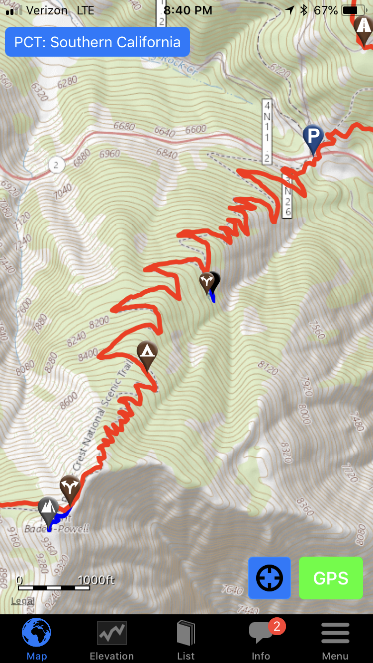
Beginning at the low point of Vincent’s Gap along the highway, the climb to the summit of Baden-Powell was approximately 4 miles with 2,815 ft elevation gain. Most of the switchbacks were steep, though at least the route was well shaded. It was a sucker of a climb.
While the summit isn’t actually on the PCT, it’s only about one or two tenths of a mile off the trail, so most hikers make the detour to the top before continuing on. The peak was named in honor of the founder of boy scouting. Boy Scouts also have a rich history on the PCT, with scouting missions an integral part of the development of many trail sections.
After enjoying the views from the top and snapping a few pictures, it was back to the trail. We still had six miles to hike before our planned campsite, which was near the next water source.
This tree, near the junction of the PCT and the trail to the summit of Baden-Powell, is estimated to be 1500 years old.
The next six miles of trail included a roller coaster of small punchy climbs and descents before mellowing into mostly flat and downhill grades. The rocky surface of much of the trail afforded many opportunities for twisted ankles, though luckily we made it through intact.
Some of the scenery toward the end of the day reminded me of the Blue Ridge Mountains.
Around 7pm, we made it to Little Jimmy Spring, a water source about .2 miles from camp. It’s definitely the coolest little water source we’ve seen on the trail. It reminded us of some of the fountains and water troughs in Japan.
Just up the trail, we reached Little Jimmy campground. A popular stopping point for the day, many other hikers had pitched their tents at the site and were sitting at picnic tables cooking their dinners or gathered around a fire. We quickly found a space for our tent, set up, and started dinner as daylight faded.
With lots of climbing for the day and a late finish (at least for us), I was exhausted. After dinner we packed up all our food stuffs and any other fragrant items and put them in the bear boxes provided by the campground since this area has seen bears.
Camp chores done, I melted into my sleeping bag. It’s good to be back on the trail.


