Day 0 – Arrival at the Grand Canyon

This morning we woke for the last morning of our five week stay in Flagstaff, Arizona. Fresh off an October of sunny days, crisp blue skies, and beautiful fall colors, November was so far presenting more of the same. Perfect conditions for our next adventure: the Grand Canyon Rim to Rim to Rim hike.

Fall colors on the slopes of Arizona’s Snowbowl in Flagstaff.
When we’d decided to make Flagstaff our base for much of the fall, I’d taken note of how close we’d be to the south rim of the Grand Canyon. While we’d visited the Grand Canyon before, it had really been more of a sightseeing stop through.
We’d visited in March of 2018 and some of the upper reaches of the main trailheads were still slick with ice and snow, particularly in the areas where the trail was perpetually tucked into the shade, canyon walls blocking the high altitude sun from working its warming magic. We’d contented ourselves to enjoy the scenic viewpoints and some brief jaunts between them.
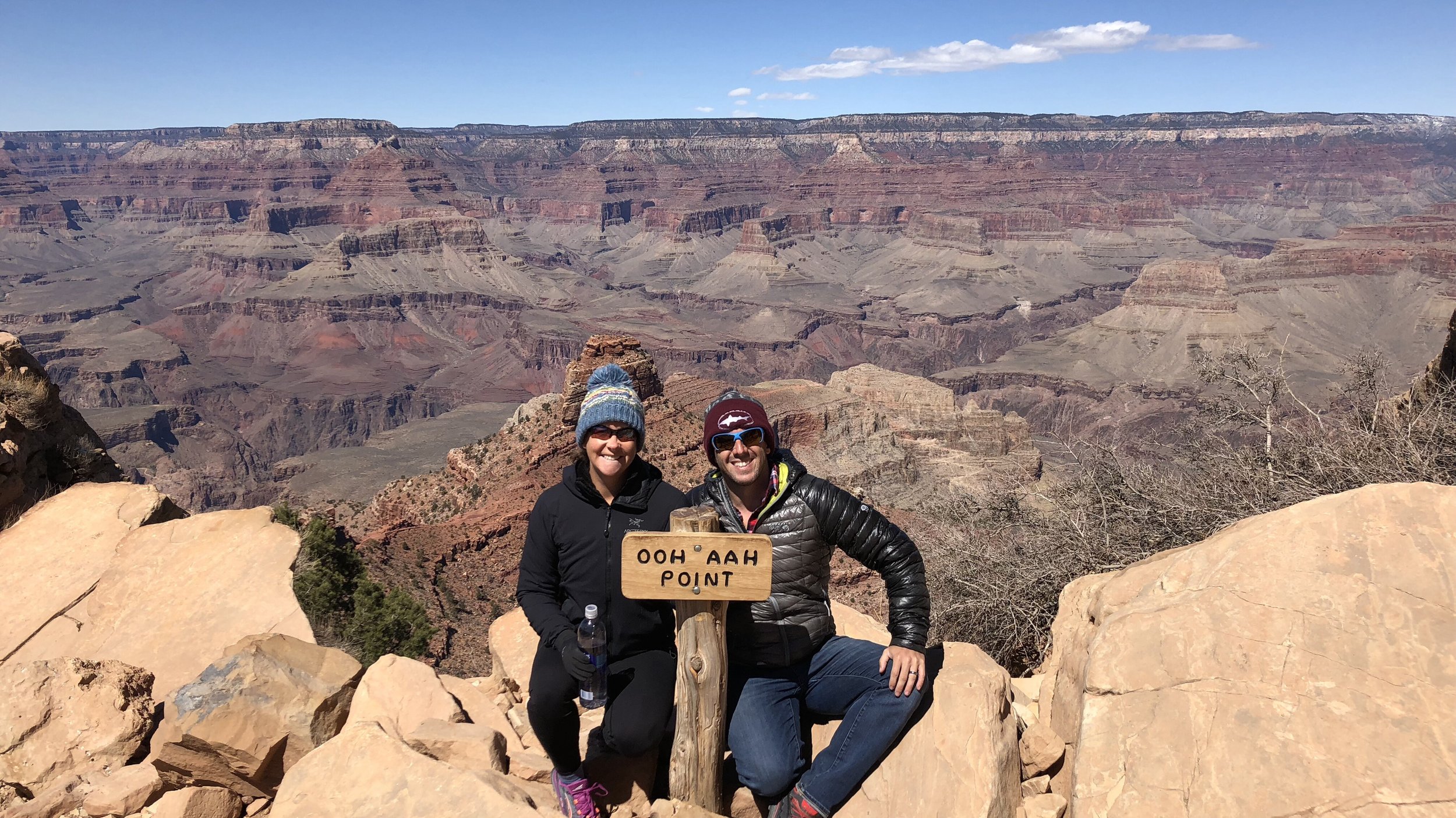
Our 2018 visit to the Grand Canyon. Ooh Aah Point on the South Rim’s South Kaibab Trail.
Now that we were going to be in the area again, I started looking into the Rim to Rim to Rim (R2R2R) trail, a hike that was high on our bucket list of trail adventures. Likely the most famous hike within the canyon, the R2R2R route is exactly that, a spectacular roundtrip journey from one canyon rim to the other and back again, descending to the depths of the canyon and over the Colorado River (twice) along the way.
Along with rafting the Colorado River, the R2R2R trail is the quintessential adventure below the rim of the Grand Canyon and is popular with both hikers and trail runners. Less than 1% of visitors descend below the canyon rim, so it also provides an experience away from the tourist bus masses along the top.
All this said, it is not for the faint of heart. The roundtrip journey is ~44 miles, includes approximately 11,444 feet of elevation gain, and is host to dramatic temperature changes, with temperatures at the bottom of the canyon often soaring high above those at the rim, even into the shoulder months.

Fun times.
We had always been keen to make the hike. Why not now?
In August, I started doing a bit more research into logistics and typical early- to mid-November conditions within the canyon. November could potentially be a tricky month to plan for since it was impossible to know how early winter would descend upon the canyon. Snow was a possibility, particularly along the north rim, which sits 1000 ft higher than the south rim.
However, once I really started looking into it, November was looking like a great month. Most of the trail reports, photos, and videos I saw made November hiking in the canyon look phenomenal. The temps in the canyon would be a bit cooler, some autumn colors lingering, and with fewer people visiting as it approached winter, it would be easier to secure backcountry camping permits.
Even if there was an early snow on the north side, it was unlikely that it would affect much of the trail beyond the first mile from the north rim. Outside of an epic snowfall, even this could be handled with basic snow hiking knowledge and the appropriate traction on our feet. We had plenty of experience with snow hiking, so I wasn’t worried.
If the conditions turned out to be truly terrible, we could simply defer our hike permit to a future date.
I decided to apply for permits.

Our plan: hike from the south rim to the north rim and back, taking the South Kaibab trail into the canyon and the Bright Angel trail back out.
When you send in the application, you submit two possible itineraries. This has to be done by mail, by the way. Actual take-it-to-the-post-office physical mail. Which, since we were out of the country at the time, was a bit of a hassle. I emailed our completed application to my brother to print who then gave it to my mom to take to the post office.
After all this, a week or two later, you get an email about the status of your permit.
Both of the itineraries I submitted were rejected. Womp, womp.
Our first choice had been to hike from the south rim, doing the hike in two days (one day each way), spending the night at the campground along the north rim. Apparently this campground was full for our dates. No go.
Our second itinerary was also rejected, again because one of the campgrounds I’d selected was full for our dates. This itinerary had been to start at the south rim, hike to Cottonwood Campground on day one (~14 miles), hike up to the north rim and back down into the canyon to the Bright Angel Campground for day two (~21 miles), and then hike the last ~9-10ish miles back to the south rim on day three. No go.
At this point, since they are emailing you, you can now just email back and forth with them until you get dates/campgrounds that are suitable. Why, you might ask, couldn’t you just email them the permit application in the first place? I don’t know.
At any rate, all of the rangers were very pleasant to work with and it only took a couple emails to determine an allowable itinerary based on campsite availability. This is mostly because only one campsite along the route had availability. And so, our approved itinerary, beginning from the south rim:
Day 1: South Kaibab TH to Cottonwood Campground (~14 miles)
Day 2: Cottonwood CG to the North Rim and return to Cottonwood CG (~14 miles)
Day 3: Cottonwood CG to South Rim via Bright Angel Trail (~16 miles)

Just getting our bearings.
This itinerary would probably work out for the best.
For starters, it obviously splits up the mileage pretty evenly, which is nice.
Also, since it’s November, there is less light in the day. Sunrise is currently around 6:50am and sunset around 5:28pm. At the base of the canyon, it’s possible we will be in the shade a little earlier in the evening and possibly later in the morning, so not having any mega 21+ mile days is probably a good thing.
Finally, since we are staying at the same campground two nights in a row, we can leave behind our tent, sleeping mats/bags, extra food, and anything else we don’t want to carry for our hike to the north rim and back on day two. That would mean less weight in our packs, which is always a good thing.
And so, we were set on our itinerary. Having settled this all over email, you may think that your application process is over.
It is not.
At this point, acceptable itinerary at hand, you must FAX this back to them. That’s right, FAX. Some people reading this might not even know what a fax machine is. Or a PHONE LINE for that matter. I asked the kind park rangers of the Grand Canyon if there was a process to submit the final application that was of this century.
There was not.

Anyone have one of these laying around?
Still out of the country, this was another hassle. Most of the online e-fax sites look dodgy. And why shouldn’t they? Who needs to send a fax? Dodgy people, probably.
To use e-fax services – should you be so bold – they generally require you to pay a subscription (no one-time-use options). For those that advertise a free trial, that ‘trial’ – it turns out – doesn’t even include the ability to send an actual ‘fax’. (I know because I tried with two different services. What exactly are you trialing if you can’t send a fax?)
After some scrambling, my soon-to-be-sister-in-law was able to use a one-time online fax trial thingie that she had – that did include the ability to send/fax something – to e-fax the completed form for me. What an ordeal. Thanks, Madison!
Only to get my final permit by…. EMAIL!
Whatever. We had our permit!
(PSA: They are moving the permit application/reservation system to the online recreation.gov site for 2024. No more faxing, I was told.)
Now this flashy permit is affixed to the back of my hiking pack and tomorrow it shall venture into the canyon!
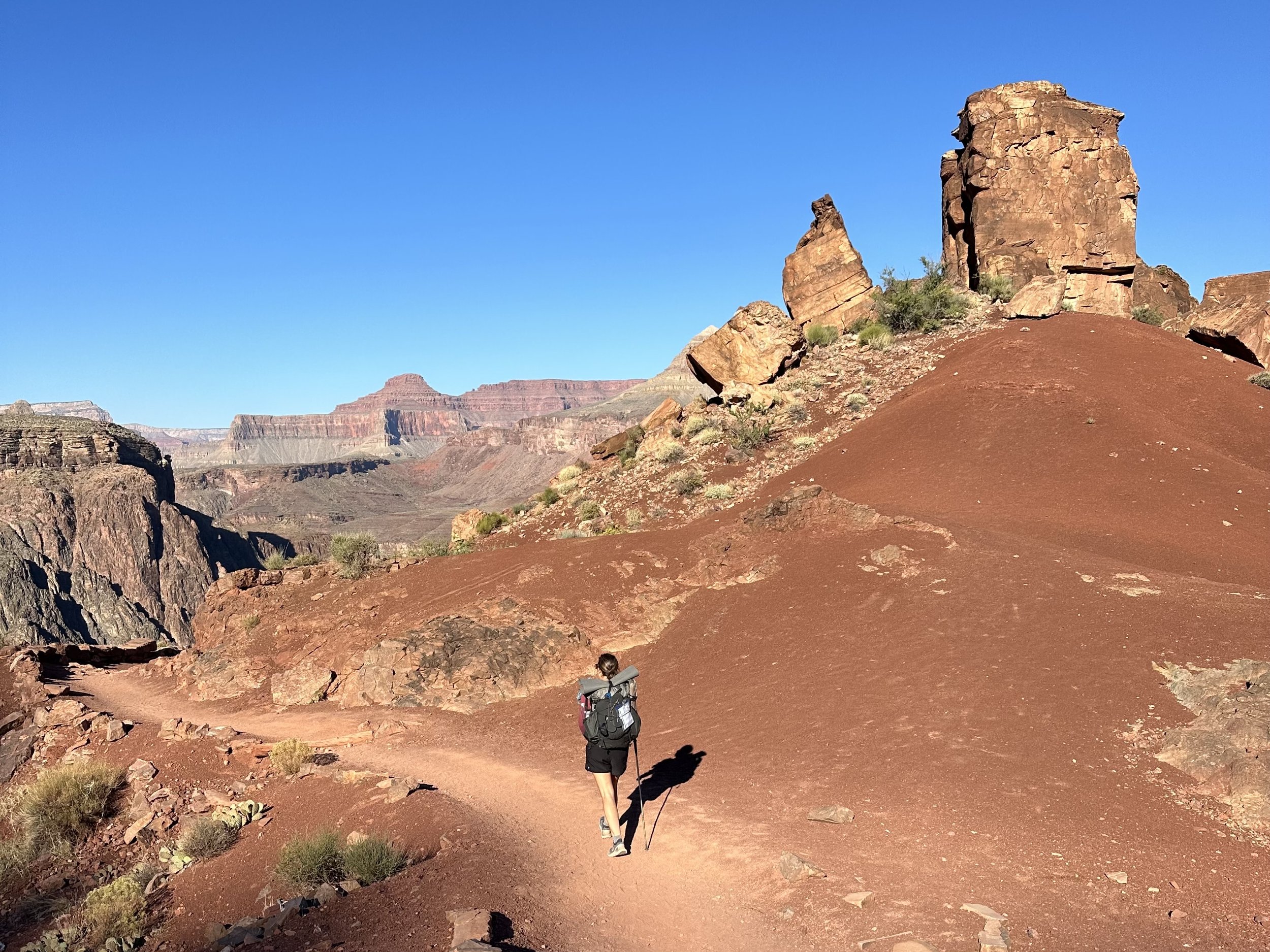
Flash forward to permit and I sauntering down the trail.
After a slow morning and one last stop for a breakfast bagel sandwich at Biff’s Bagels in Flagstaff, we hit the road, making the hour-and-a-half drive to the south rim of the Grand Canyon.
The drive passes through some small towns, each gearing you up for the main event with businesses that all have ‘Grand Canyon’ in their name. Grand Canyon Outpost. Grand Canyon Inn. Grand Canyon Storage.
And then there’s Flintstone’s Bedrock City.
Anything to capitalize on the geology around here.
In between the small towns, there’s a lot of wide open, windy landscape of small scrubby desert bushes and the occasional outpost of scattered trailers and mobile homes. You would be completely unaware that you are approaching such a magnificent chasm.

Grand Canyon Visitor Center South Rim.
We pulled into Grand Canyon Village in the early afternoon and spent the next hour or two walking around the rim trail. The day was a bit windy and the sky above the canyon was hazy in the afternoon sun. Otherwise, it was a gorgeous day and it’d be hard not to be impressed with the enormous canyon before you, layers of history writ large on the landscape. Reds and whites and yellows and oranges. Hundreds of millions of years stratified before your eyes. A lot of rock. A bit of green. A few glimpses of river.
Walking along the rim trail, we pointed at pieces of trail we could see snaking through the canyon. Trail we would be walking the next few days. The bridge over the Colorado River was barely visible from the south rim. An oasis of trees would hold the buildings and cabins of Phantom Ranch, where we could stop for cold drinks.

You know, proof we’re here.
After walking around for a bit, taking pictures at some of the scenic overlooks, and looking through the small but well presented Yavapai Geology Museum, we made a quick stop into the Visitor Center to square away a few questions we had about shuttles to the trailhead in the morning and where we could leave our car parked while we were out hiking.
Despite the fact that I had called the Backcountry Information Center only a couple weeks ago to answer these same questions, everything I had learned on this call was either (1) already wrong when they presented the information or (2) wrong now, after only a couple short weeks. What does this teach us? Preparation is futile.

This unhealthy stash can only mean one thing…
Now armed with the correct information, Shawn was happy to learn that the first shuttle was not until 7am (rather than 5am). We can also keep our car parked in any lot while we are out, which makes the morning shuttle situation even easier than when we thought we’d be confined to the parking lot by the Backcountry Information Center (from whence all the disinformation came… )
With that, we headed to the hotel area to check in. The hotels within Grand Canyon National Park are nothing special, other than being along the rim of the Grand Canyon. This said, I’m sure some are better than others. And those were probably all the ones that were sold out when I made our booking. No matter what hotel you end up in, it is not cheap, because you’re on the rim of the Grand Canyon. It was worth it to be situated in the park since we will need to get an early start in the morning.

Pink glow of the north rim at sunset.
In the evening, we walked along the rim for sunset. The wind had picked up and the evening was cold. The sun was behind us as we looked out over the canyon, its light creating a band of glowing pink rock along the upper reaches of the north side of the canyon. The canyon below was swathed in shadow. Tomorrow night we would be camped just past the base of the climb to the north rim. Probably bundled up in our sleeping bags at this early evening hour.

Goodnight sun.
After watching the sunset, we grabbed a typical hiker dinner at the Bright Angel Lodge: hamburgers and fries. Actually bison burgers. So, a fancy hiker dinner. Like the hotel, the food was nothing special. All of the draw here belonged to the beast of a canyon out the back door.
Tomorrow we head into the belly of the beast.