Hot Mess & Butters: At It Again! For Our Next Trail...
That’s right, we have big news! Shawn and I are coming out of (relative) thru-hike retirement and hitting the trail once again! This time, we’ll be tackling the roughly ~3100-mile Continental Divide Trail (CDT).
The CDT, Appalachian Trail (AT), and Pacific Crest Trail (PCT) make up what is known as the ‘Triple Crown’ of U.S. thru hiking trails, each traveling along/near the longest mountain ranges in the U.S. While the AT traverses the Appalachian mountain range and the PCT routes through the Sierra and Cascade ranges, the CDT runs along the spine of North America, traversing the Great Continental Divide and the Rocky Mountains from Mexico to Canada.
Many of you who followed our PCT journey may remember me saying that, while we enjoyed our thru-hike, we would never do a long trail again...
Welp, changed minds!
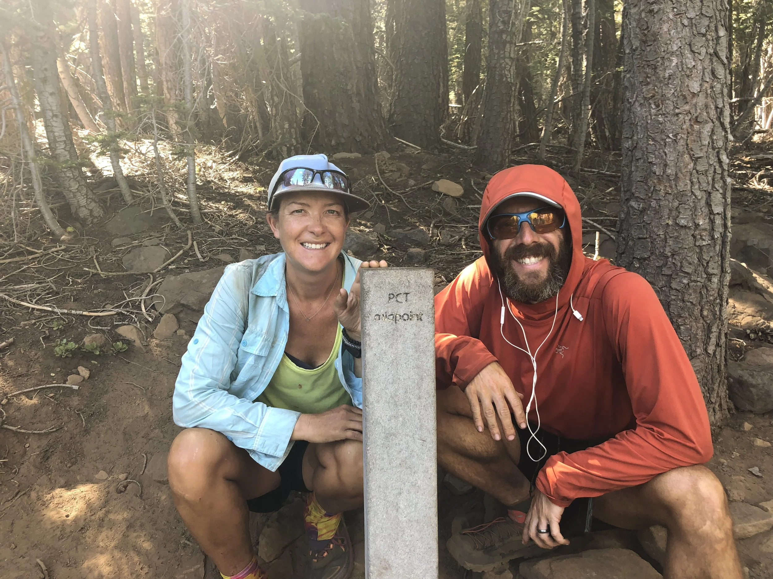
Here we are on the PCT, pleased as punch to be at the halfway point of the long journey to Canada.
Like any great adventure – with time, the sweat, pain, exhaustion, and discomfort fade away. You are left with only the good memories: the phenomenal landscapes traversed, the unique communities visited to rest and restock provisions, and the amazing friends you made along the way.
In short, with a bad memory, anyone can be a repeat offender, setting out to accomplish – once again – something they said they would never do again. Collectively, we’ve done five Ironman races, so obviously there is a screw loose somewhere.
In reality though, we just really like hiking.
In the six years since we’ve hiked the PCT, we’ve done many shorter hiking adventures all over the world, from day hikes in Brazil, Iceland, Argentina, and Australia, to multi-day to multi-week hikes in Bhutan, Peru, Norway, Pakistan, England, France/Italy/Switzerland, Chilé, and many other countries. We’ve hiked as far north as Svalbard in the Arctic and as far south as landings in Antarctica.
In short, this announcement should surprise no one.

Freezing our tushies off on Bhutan’s Snowman Trek, October 2022.
And so, here we go again!
Like the PCT, I will be blogging each day of our hike. If you’d like to follow along, you can subscribe here to receive email notifications when a new blog is published.
We’ll also post pictures on Instagram from time to time, so be sure to follow us @wanderin.thru if you’d like to track our journey.
While I plan to blog every day, we won’t necessarily have cell service every day. So if you don’t get a regular blog notification to your inbox, don’t worry. We’re (probably) not dead. But we might be. In which case, no more blogs.
While there will (hopefully) be months and months of blogs for us to fill you in about the Continental Divide Trail in all its glory, I’ll leave you with a bit of basic information for now.

Just going on a little hike far above the Arctic Circle along the northern edge of Spitsbergen, Svalbard. July 2023.
THE CDT, IN A NUTSHELL
We’ve already hiked from Mexico to Canada. Why do it again?
While the PCT and CDT share some characteristics... like being very long... they are also wildly different beasts.
Like the PCT, the CDT also spans from Mexico to Canada. While the PCT routes through the westernmost states of the continental U.S., the CDT stretches along the backbone of America: The Great Continental Divide, traversing New Mexico, Colorado, Wyoming, Idaho, and Montana en route to the Canadian border.

Continental Divide Trail. Map credit: National Geographic Maps/CDTA.
Of course, you can also hike southbound (SoBo), starting in Canada, but we’ve heard this is less of a struggle, so naturally, we will be hiking northbound (NoBo).
I’m including acronyms here that I’ll likely sprinkle into future blogs when I’m tired and don’t want to type so much. Take notes.
As the spine of U.S., the Continental Divide separates watersheds that flow into the Pacific, Atlantic, and Arctic oceans. Along the trail, we’ll pass through 20 National Forests, 13 BLM Wilderness and Wilderness Study Areas, and 3 National Parks, including Rocky Mountain, Yellowstone, and Glacier National Parks. Mostly this means lots and lots of conserved, protected, and/or managed pubic lands.
We’ll traverse desert, high mountains, grasslands, ‘sky islands’ of high pine and conifer forests rising abruptly from basins of grasslands and shrub, Ponderosa forests, sagebrush basins, temperate forests, and a number of other ecosystems.
In short, we’ll traverse some of the most dramatic and remote country in the U.S., which seems as good a reason as any to start walking.

Hiking in the Lofotens, Norway. So spectacular it doesn’t even look real. July 2023.
Among the Triple Crown hikes, many save the CDT for last. This is mostly because it is widely regarded as the toughest of the three, the most remote and rugged of the trails. We’ve opted to hike the trails more in order of interest (sorry, Appalachian Trail... maybe some day).
Compared with the PCT and the AT, the CDT is far more remote, with the trail located further from population centers. This will mean greater distances between towns (average 5-7 days) and often longer, more difficult hitches to get to those towns.
The CDT is also the most rugged of the trails. In some areas there really is no worn trail, but rather a general direction to follow. As such, it will require more careful attention to navigation.
Finally, though an official route exists, there are far more options for alternates along the CDT than exist along the PCT or AT. Many of the alternates are more popular than the official trail, allowing hikers access to unique landscapes nearby, easier access to water, or more direct routes into town. Some alternates seek to avoid road walks or detour around areas with a significant number of blow downs (fallen trees). Some allow for a bit of peak bagging. And still some exist to avoid high ridge lines in poor weather or divert around dangerous snowy terrain or potential avalanche risk areas.

Happy as clams at the finish of the PCT, the northern terminus at the U.S.-Canada border, in September 2018. If all goes as planned we’ll finish the CDT sometime this September.
In short, in many ways, the CDT is a bit of a choose-your-own adventure trail. In addition to planned alternates, as with any long distance trail, each year brings unique challenges that may require reroutes, detours, or creative on-the-fly alternates. Wildfires have become an increasing concern along all of the long trails. On the PCT, we took at least three reroutes to avoid current or past burn areas.
All of this said, it’s difficult to report the expected total mileage for a continuous footpath from Mexico to Canada. Our final path from Mexico to Canada could take many forms and we’ll make route decisions based on the weather, snow, wildfires and other potential circumstances as we progress our way up the trail.
In the end, our goal is to keep a continuous foot path following the official trail as much as possible, but we will certainly take advantage of some of the most popular scenic alternates. Other route variations we will play by ear. Most CDT thru hikes land somewhere in the 2700 to 3100 mile range and take, on average, right around five months - give or take.
Just typing that makes me very tired. That’s plenty of info for now.
Stay tuned for more updates coming soon, we hit the trail in just over a week!