Day 13: Tagnag to Gokyo + Gokyo Ri
Approximate Trekking Time: 2 hrs. to Gokyo; 3 – 4 hrs. roundtrip to Gokyo Ri
Distance: 8.9k / 5.5 miles
Overnight Elevation: 4750m / 15,584ft
Despite being one of our favorite lodges, the Cho La Resort was one of the coldest nights for me, my sleeping bag feeling less warm than usual. As usual, the windows were etched in frost when we awoke. Before leaving the hostel, the owner called ahead to Gokyo to assure that we would have four rooms waiting at the Namaste Lodge when we arrived, since Gokyo was supposedly very busy. He also served us complimentary cups of delicious steaming milk tea, and after drinking them around the dung-fueled stove, we set off for Gokyo.
Our hike from Dragnag to Gokyo took us through the Ngozumba glacial moraine: up, down, and around slopes of rocks and boulders and by tiny frozen lakes and ponds, which we stopped to throw rocks in – some busting through, some lodging partway into the top layers of the thick ice, and some just bouncing across the ice, their bounces sending a fun warping echo through the rock field. We followed the myriad of cairns and trails as best as possible, eventually emerging upon a grassy hillside with a view over Gokyo.
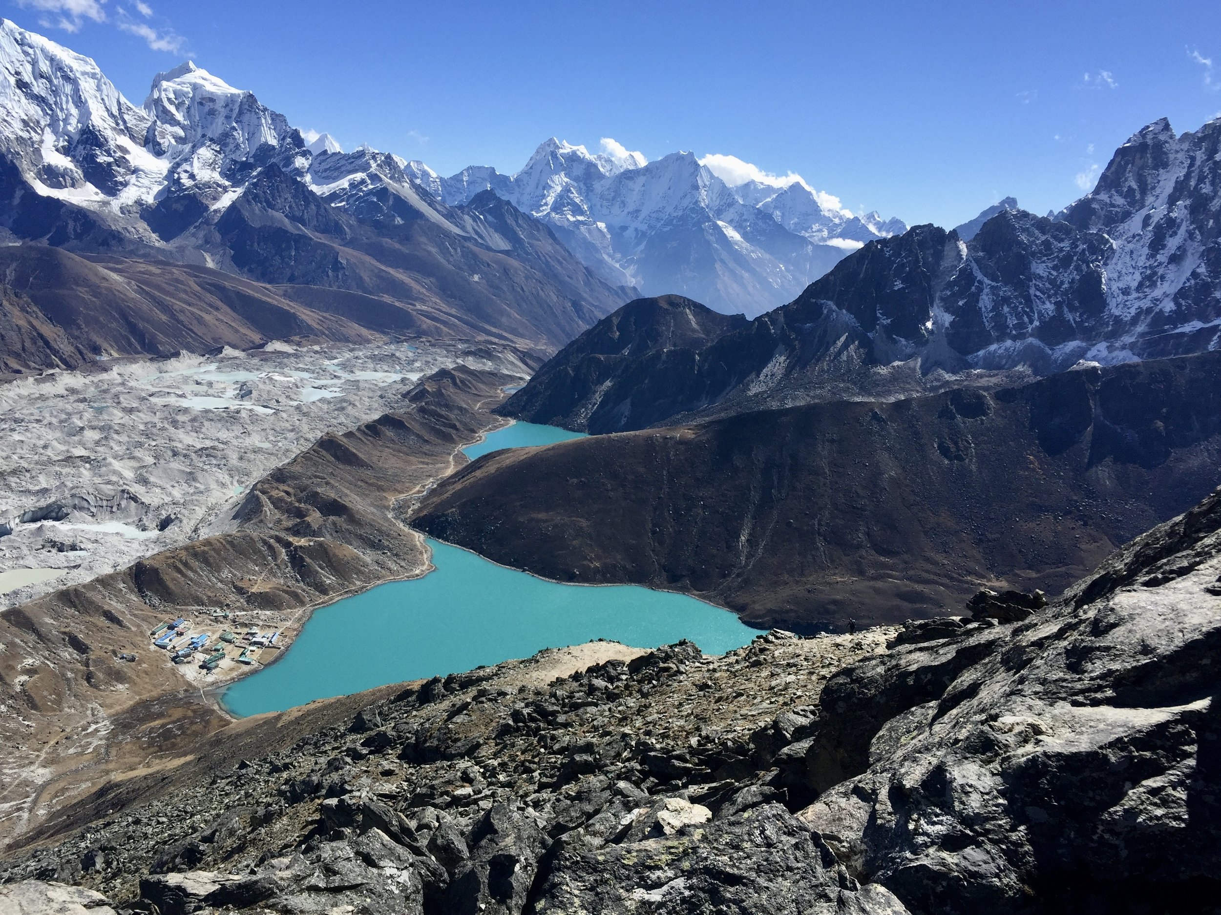
One of the best village settings in the Himalayas, Gokyo (4750m/15,580ft.) is situated along the eastern bank of a beautiful, gleaming turquoise-colored lake, with Gokyo Ri along the northern side of the lake, the trail climbing up to its peak looking steep and stiff from a distance. The lake, Dudh Pokhari, is the third of six sacred lakes that stretch from south to north of Gokyo. After taking some obligatory photos atop boulders with the spectacular view in the background, we hiked down into the village, greeted by the odd brown warbling birds we had seen several times over the past few days – looking something like a cross between a pigeon and a pheasant (I couldn’t find their proper name, and I’m sure birders would cringe at this description).
The Namaste Lodge welcomed us with warm cups of mango drink and, after settling in rooms and unpacking our bags, we set out for Gokyo Ri, walking across the rock bridge where water trickled into the northeast edge of the Dudh Pokhari to reach the trailhead.
The trail climbed steeply over soft sand and then rocky trail, zigzagging its way up a number of possible paths past cairns. Though it became rockier, there was a trail all the way to the summit of Gokyo Ri (5360m/17,581 ft.), where tattered prayer flags flapped in the winds, the windiest of the summits we’d climbed. Prayer flags wrapped around a chorten housing a small Buddha figure. From the top, there were clear views of Cho Oyo, Everest, Lhotse, Makalu, Cholatse, and Taboche, as well as the sacred lakes of Gokyo stretching to the south of the peak. The view atop Gokyo Ri was also the first vantage point from which Mt. Everest clearly stood out as the highest mountain on the landscape. Chilly at the top, we didn’t linger long, taking the requisite landscape and group photos before heading back down to our lodge.
With the day’s hiking completed, we spent the rest of the afternoon drinking tea in the dining room and playing a new card game that Shawn had learned from another group of travelers in Dzhonglha. Quite addictive, we played the game (Kaboom!) a lot over the next few days in Gokyo.

