Day 1: Lukla to Phakding
Approximate Trek Time: 2-3 hours
Distance: 7.9km / 4.9 miles
Overnight Elevation: 2,610m / 8,563ft
Our journey to the Everest region began with a short flight from Kathmandu to Lukla, the unofficial gateway to all Sagarmatha (Everest) National Park trekking. While it’s possible to hike to Lukla (approx. 5-7 days from Jiri), the vast majority of trekkers opt to fly into Lukla to begin their journey. The flight from Kathmandu to Lukla is only about 30 minutes, and in our opinion, was part of the magic of the journey to the world’s highest peaks.
The Flight…Our morning began with a very early cab ride through the dark streets of Kathmandu. The domestic terminal at Kathmandu’s Tribhuban Airport included a small side door for employee entrance and a large garage door for passenger entrance to the departing flights. Here, we waited, the terminal not yet open. We had been told by one of the staff at Elbrus House (our guesthouse in Kathmandu), “airport opens at 6:00”. Holding tickets for a 6:15am flight, this seemed unlikely, though wasn’t far from the truth. While a couple of solid cues had formed before we arrived, these were quickly dissolving as time marched forward, and as guides and porters marched their group’s equipment and duffels – along with their group – straight up to the doors past the lines. The cues quickly became a messy throng of trekkers, which blobbed forward when the door was finally rolled up just after 5:30am.
We queued ourselves through bag security as best as we could, our bags taking a trip down a conveyer belt that had no visible x-ray scanning system or authoritative figure examining contents behind a screen. But, having gone through one end of the belt and popped out at the other, all bags were approved. Onward!
From here, we lined up at the Simrik Airlines desk. All around us, other flight companies checked in their customers. Our desk sat empty. Hmmm. Eventually a man showed up at the desk… “Waiting,” he said, and walked off again. After a long while, he emerged with a man looking very expedient in his task. It appeared that their computer system was down. No worries though, he quickly gave up and started scribbling all necessary information – ticket numbers, passport info, and baggage weight – onto a scrap of paper. Seemed legit. After weighing our packs, we were weighed, and then pushed off toward the departure area with our boarding passes.
In the boarding area, we waited for our flight announcement. While announcements for the Tara Airline flights had come through a very official speaker, the announcement for our own flight was shouted by an airport traffic operator through the door, “Simrik flight!” he called. “Red bus,” he instructed as we marched forward with our tickets. They wasted no time. As soon as our red bus was full with its 15-ish passengers, it was off – driving the short distance to our small passenger plane.
Looking at the plane, I had to laugh, remembering our guesthouse owner, Raj, helping us book the tickets in Pokhara. Looking through different airlines he stated, “GOMA, very good. Two engines. Simrik same – also two engines! Good plane!” He had placed a lot of calls to get us on an early morning flight. “First flight better. Second or third – later – no good. Sometimes no fly.”
We were definitely among the first flights and the crew wasted no time getting the bird off the ground. Despite the check-in process being fuddled and slow, the airline was now all efficiency as the plane sputtered to life, heading swiftly to the runway at 6:15am sharp. There is only so much time to get flights into and out of the mountains before clouds or weather (or both) close in and flights are delayed – canceled – rescheduled. On a clear day, Lukla probably receives 50-60 flights, all before noon.
The flight attendant made her way down the aisle with a basket. Small wrapped candies on one side and on the other…, mmm candy. While I had given little attention to what was on the other side of the basket, it wasn’t long into the flight that I realized it was wads of cotton for your ears because the plane was VERY LOUD. I looked around at the other passengers. It seemed we had all made this mistake, distracted by the “Lacto-Fun” candies. I quietly hoped that the fun would not include a toilet.
The views from the flight were amazing and further highlighted the fact that the vast majority of Nepal is nothing but mountains – and very large hills that in many parts of the world would also be called mountains. We flew high above some, and so close to others we could practically see their inhabitants eating breakfast. Looking through the cockpit window (since we were close enough to do this in a small plane), it often looked as though we were about to fly directly into a mountainside. The obstacle warning blinked nearly constantly from the cockpit, “terrain ahead”. I stopped looking into the cockpit.
At one point, Shawn turned to me, showing me the altitude reading on his watch – 11,749 ft. (3581m) – “we’re flying about 6,000 feet lower than we’ll be hiking soon!”. It was an amazing thought. We were far above much of the mountain landscape, and in a few short days we would be above this elevation, eventually trekking over passes and peaks at greater than 18,000 ft. (5480m).
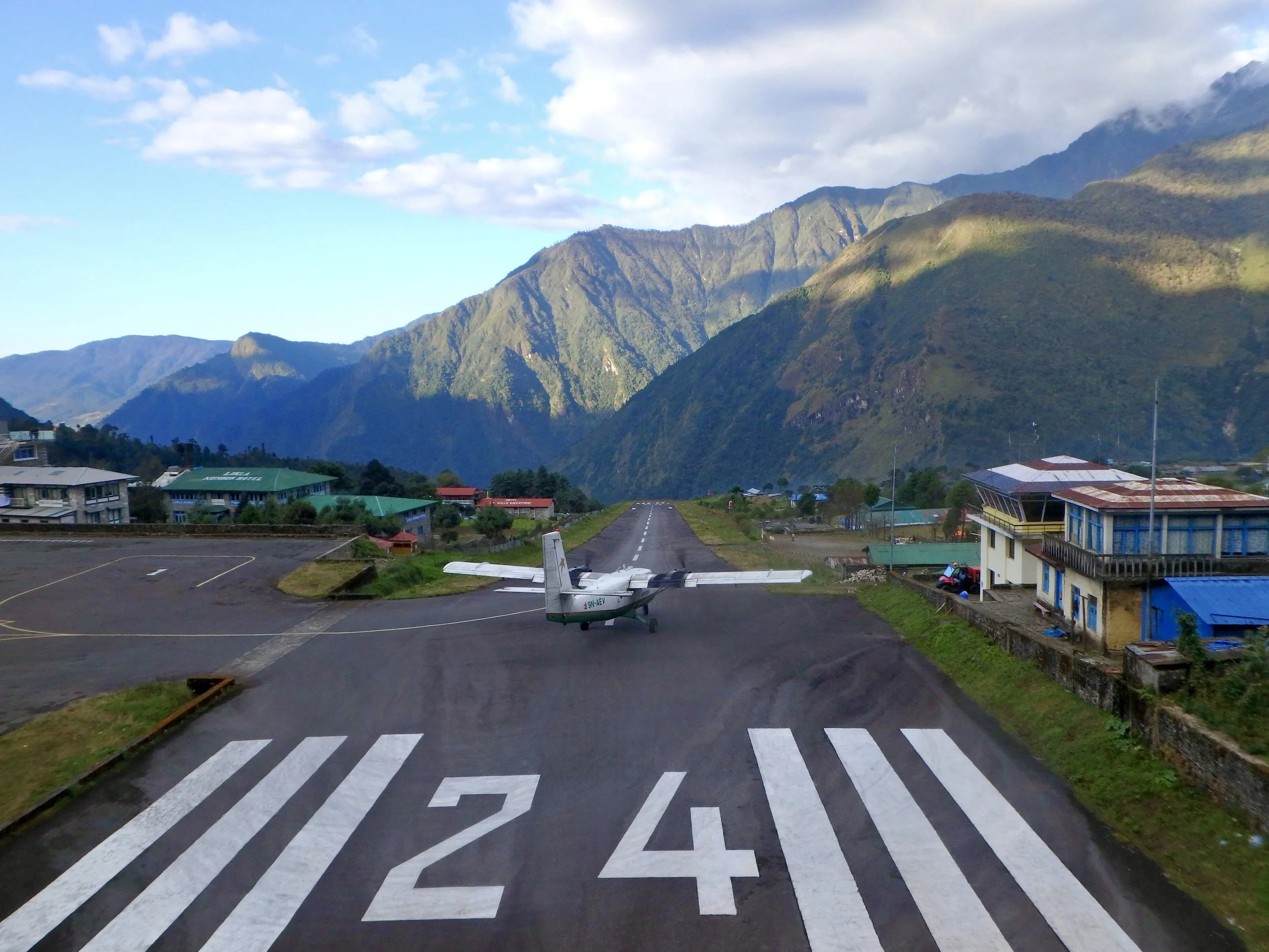
Soon, the plane curved through a pocket in the mountains and we were heading straight toward the runway – the very short, uphill runway. It was unreal how short the runway was. With limited space, planes landed at the downhill end of the slope, slowing quickly as the runway angled upward toward the mountains, which would surely stop anything that didn’t stop in time on its own. Thankfully, we did.
The plane cruised quickly into the tarmac area in front of Lukla’s small terminal. In an astounding display of efficiency, our flight’s passengers and baggage were unloaded, the new passengers and baggage bound for Kathmandu were loaded, and the plane was heading back down the runway for take-off, all in a span of approximately five minutes. Other airlines: take note!
Grabbing our packs, we headed out of the airport gates and stood along the pathway above the runway for a bit, just watching planes take-off and land, in no rush to get out of Lukla quickly since our hike for the first day would be short. It was truly the most stunning airport we’d ever flown into… from the spectacular scenery of the surrounding mountains to the astonishing runway and quick take-offs and landings, it was a scene you could watch all day.
The Hike…Eventually we pulled ourselves away from the airport area and headed through Lukla, making a quick stop at the kitschy Lukla “Starbucks” for a cup of joe on the way out of town. After registering at a permit checkpoint, we headed down the trail through the Pasang Lhamo Memorial Gate, named after the the first Nepali woman to summit Mt. Everest. Just beyond, a dull white moss-covered memorial chorten was dedicated to the victims of a 2008 Yeti Airlines crash.
One of the best things about the Khumbu region: zero roads. No cars, no buses, no motorcycles… no bicycles even. No honking. Villages were connected only by well-worn trails, beat into the earth from hundreds of years of trade, travel, and trekking in the region, traversed only by the feet of locals, trekkers, pack animals and livestock.
The wide, well-maintained trail wound its way through pine and other hearty trees and bushes, the trail sometimes paved in inlaid stones and others more natural dirt and rock. Passing by waterfalls, over bridges, past small vegetable fields, and around chortens, stupas, all sizes of both brightly colored and more weathered prayer wheels, and large boulders and mani walls with stone tablets engraved with Buddhist mantras and sacred scripture, we hiked through the villages of Cheplung (which we pronounced in the same manner of the sound of a fat rock being dropped into a lake), Thadokoshi, Ghat, and Chhuthawa before arriving in Phakding.
Phakding (2610m/8560ft) stretches from north to south along the Dudh Kosi River. We walked through the bulk of the village, crossing a suspension bridge to the other side of the Dudh Kosi, where we checked out a few lodges before staying at the Mountain Resort, situated high upon a hillside overlooking the river. Speaking with several lodge owners in Phakding, it was here that we learned that everything at the lodges along this trek would be priced a la carte, with separate charges for rooms, showers, Wi-Fi, and charging. The take home: fewer showers and less time online. Check. I busted out the playing cards.
Walking back through Phakding later in the afternoon, it seemed that if it was an actual village (other than guesthouses, restaurants, and toilet paper and candy bar shops), the homes must be hidden either up or down the surrounding hillsides. Popping our heads into a few bars, we also learned that the beer prices (and for that matter, prices of everything) would be much higher in the Everest region than they had been along the Annapurna Circuit. Because there are no roads throughout the Khumbu region, all goods are hauled in on the backs of porters, yaks, horses, and donkeys (and the occasional helicopter in some regions), so everything carries a higher price tag, with prices rising as quickly as the altitude.
Damage from the 2015 earthquake was visible along some portions of the trail, though in some cases it was difficult to discern between rebuilding efforts due to earthquake damage and new construction, which is also common through the region. One lodge in Phakding where it was not difficult to determine earthquake damage was Jo’s Eco Cottages, situated along the river below Mountain View. The small cottages had been reduced to rubble, with only piles of crumbling bricks atop blank foundations, and no current signs of reconstruction. While some villages received more damage than others, on the whole we found that most damages had been or were in the process of being repaired and most lodges were open for business.

