Day 4 - Getaria to Deba (+)
Date: Tuesday June 18
Start: Getaria, Gipuzkoa, Basque Country
End: (beyond) Deba, Gipuzkoa, Basque Country
Daily Mileage: ~15mi (24.1km)
Total Mileage: ~49mi (78.9km)
Today was a long and tiring day. Though it was actually our shortest (hiking) day thus far mileage-wise, the day included the most climbing/ascent that we’ve had thus far – much of which was very steep. The views were incredible – but we worked for them.
After Breakfast #1 – coffee, ham & cheese paninis – we rolled out of Getaria, past the statue of Elcano and down the street into the hills. Pilgrims were about.
We had read that today would be a lot of ascending and descending with little flat, though throughout he morning, we found that there were plenty of flat to very easily rolling stretches between the bigger climbs and descents.
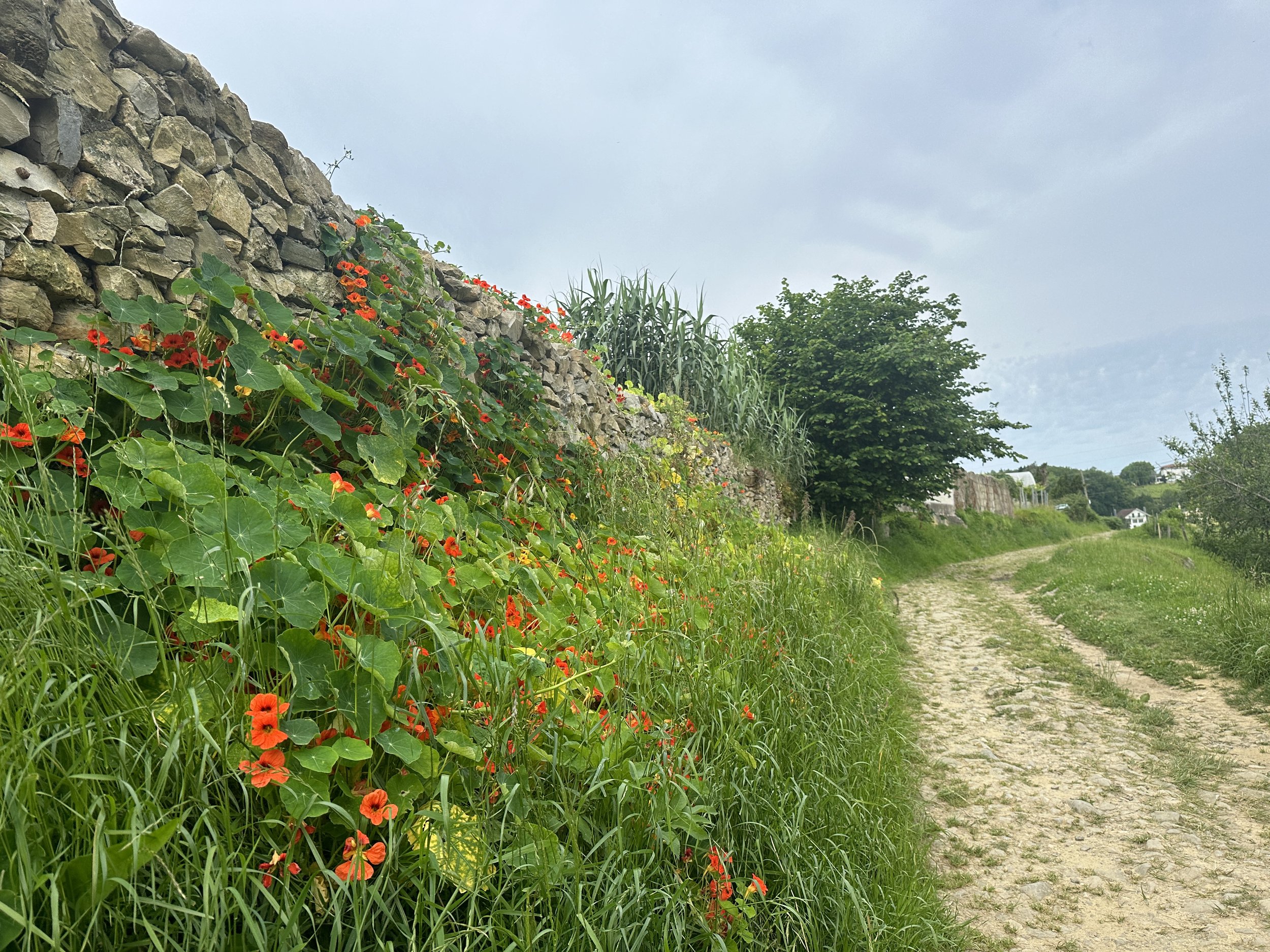
The morning took us between stretches of trail, cobbled pathways, and gravel – or occasionally paved – country roads, passing vineyards, stone walls and homes with flowering vines cascading down the facades, and plenty of cattle pastures. I sent my niece a picture of a cow that was the same color as the calf (Reeses) she is currently ‘raising’ through a ‘Beef Buddies’ (🤣) program.

We wound through a vineyard and up through the hillsides to the small hamlet of Askizu, where the Gothic-style Iglesia de San Martin, one of the oldest Christian churches in Gizpuzkoa, stood sentinel. And quiet.
The road through the hamlet routed directly along the hilltop, with views toward the valley and sea on either side. We passed farmers working in their plots, clucking chickens, and the local albergue (pilgrim inn) as we continued down the road to more views of rolling green hillsides, vineyards, and the sea.

The red-tiled roofs of the town of Zumaia in the background.
Winding along the hillsides, the city of Zumaia came into view below, red-tiled-roof homes and buildings set along the Ría Urola. A few more zigs and zags down the hillsides and we were walking down a city path along the river, heading for Breakfast #2.
Having hiked three miles, it was surely time for a coffee break. We posted up at table outside a cafe across the street from the river, helping ourselves to a second coffee and a ‘pastel Basque’ – a pie-shaped Basque pastry. When in Rome.

The ‘pie’ had a solid but soft cream layer inside, and was actually quite good. It also came adorned with the Basque flag. Apparently there are many interpretations of what the colors of the Basque flag mean, but the most romantic of them is this: they simply symbolize the colors of Basque Country – rolling green hills and mountainsides dotted with white homes with red-tiled roofs. (I can confirm that this is the quintessential view through Basque Country. I have at least 100 photos.)
Lingering over second breakfast may have been the result of an optimistic interpretation of how easy (and short) we thought the day would be. It was supposed to be “only” 12 miles to Deba, our lodging just a couple miles past this. Easy day, we thought.

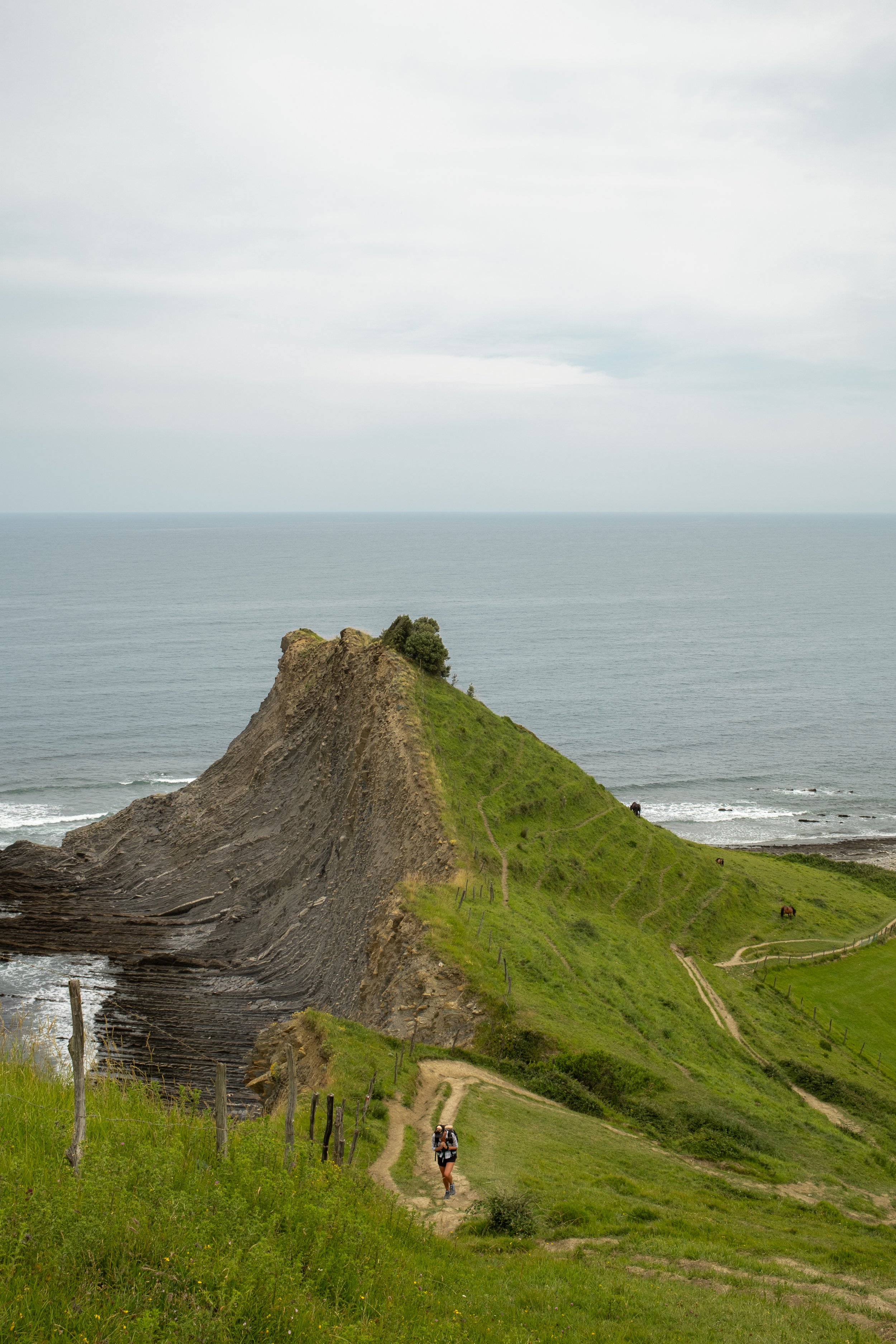
Heading out of Zumaia, we diverged from the ‘official’ Camino to take the Zumaia-Deba Geopark alternate which would stick toward a more coastal route and provide the opportunity to view some of the amazing shoreline along this stretch of the route.
The alternate was only about one mile (1.8km) longer than the official route and would offer some very unique geological coastal scenery. It would also cross paths and merge with the official route three times throughout the hike to Deba, so if we changed our minds, we could always switch back to the official/inland route.
What was NOT explained anywhere that we read about this route was how much work it was going to be. In the end, it was worth it, but man – there was a lot of very steep climbing involved. [As an edit here, later I found a section in a guidebook that I had missed that most certainly did mention, among other notables, the ‘series of tough ascents’ to return to the route to Deba. My bad.]

San Telmo Ermita
So anyway, in our bright sunny optimism, we set out. Heading through Zumaia, the route climbed up past Saint Peter the Apostle Parish and then steeply up to the San Telmo Ermita, a Renaissance-era chapel set along dramatic coastline, a setting that has been used in a popular Basque film.

The San Telmo Ermita along the dramatic coastline.
We walked around the chapel, admiring the views of the coastline. Zumaia’s beaches are apparently set on the longest continual rock strata in the world, the area famous for its geological Flysch deposits which preserve something like 60 million years of history. Sounds impressive and, I don’t know what Flysch deposits are, but the coastline here really was quite spectacular.

Descending from the chapel, we continued along a coastal path that offered some amazing views over the cliff faces. It seems this must have been school field trip day, as there were many school groups in this first, most accessible, area of the geopark – some clearly receiving lectures and filling out workbooks. If my geological Spanish vocabulary was a bit better than “rock = roca”, then this may have been interesting to listen in on.

As it was, we kept going, climbing the trail steeply above the cliff faces and around the coast before it eventually routed us back inland. After some steep climbing through fields, we merged with the official route again for a bit, which had nice views over the rolling green hillsides.
We stayed on the official route for a bit, skipping the second Geopark detour (it was very short) and following the country roads and trails passed farmland, an expansive park full of picnic tables, and a field of donkeys, including a very cute baby donkey.
This photo does not do justice to how steep this climb was.
Not far past the donkeys, we detoured once again onto the Geopark alternate. This was the longest – and we’d find out, toughest – of the alternate sections. While much of it routed through forest cover, the sections where it popped out along the coast were stunning - jagged cliff faces and striated slabs set against the rolling hillsides with grazing cattle and sheep. The juxtaposition of the dramatic coastline against the bucolic pastoral land was beautiful.

Look it was flat for two seconds!
It was also a lot of work to hike through. The trail here routed steeply along the edges of the cliff faces – nearly vertical with dirt steps worn into the pasture. After climbing steeply up, the trail descended just as steeply. It was a route I would not want to be on if it was raining. It was fairly slippy even in dry weather.

And though it was an overcast day, full of gray and diffuse light, it was quite warm – and very humid. Both of our shirts were soaked in sweat as we made our way through the climbs.
From this section, the trail routed inland again, going through a series of steep, strenuous climbs. After the first major climb away from the coast, Shawn and I stopped along a grassy slope with views toward the sea to eat the picnic lunch we’d picked up in Zumaia - a baguette, some sliced chorizo, and oranges.

From this point, we had a little over two miles left to Deba. The route continued to climb a series of steep ascents - punctuated by a bit of downhill and the occasional flat bit – mostly through forest with the occasional view back out along the coast and some fantastic cliff faces.
Though the afternoon was tough, what I will remember most – after the dramatic coastline and the tiring climbs – is the number of wildflowers we saw throughout the day – so many different flowers, so many different colors. I took so many flower photos throughout the day.

Andre Katalina Basaeliza (Chapel)
After a number of steep ascents, we reached a small stone chapel on a hillside. The day had been fairly overcast and was now mostly gray, but the chapel was beautiful, even without an astounding background. I was most happy that there was a water spicket, as I was running low and very thirsty.
After another thirty minutes of hiking along fields and rough cobbled pathways, we reconnected with the official Camino on the road into Deba, which quickly became very steep cobbled pathways and stairways descending into Deba.

Descending into Deba
What a hike. It should be noted that we saw only one other (potential) pilgrim along this route... either our timings didn’t match up or everyone else knew something we didn’t know. (Though despite being difficult, it WAS worth it).
In Deba, we went straight to a supermarket to pick up some picnic lunch foods for tomorrow, since the towns with services along tomorrow’s route are only early in the day. All packed up with some provisions, we sat in the plaza for a bit collecting ourselves before our final stretch. A family played soccer in the open space of the plaza while several people – mostly pilgrims – ate outside at a nearby cafe.

Plaza in Deba.
Most pilgrims stay in the city of Deba for this section – which seemed very wise to us (now) after the difficulty of the geopark alternate – but we had a couple miles left to complete, having booked a room at a ‘Casa Rural’ (country guesthouse) up the trail a ways.
The good news was, we were going to knock out a bit of the climb out of Deba today, so there would be less climbing to do first thing in the morning. The bad news was, we didn’t want to climb anymore today. Ha...

Luckily, the first half mile getting out of town was flat. The next half to three-quarters of a mile was the steepest... I plodded along. Happy enough, but slow on the steep ascents.
At just before 4pm, just as forecast, the skies started rumbling, thunder booming across the mountains. I was actually a little shocked. The weather forecasts have been pretty unreliable here, so the fact that a thunderstorm emerged exactly as forecasted was impressive.
And so, we were accompanied by light rain for the last mile of the hike. The majority of this was pretty gentle or flat, and I liked the pitter patter of the rain against the leaves and my umbrella.

At exactly 15 miles from our start point this morning, we arrived at our overnight accommodation, a small rural inn with a restaurant downstairs and rooms upstairs.
We were tired after the long day and in for the rest of the night – one perk of staying in a country guesthouse is there is really nowhere else to go. No town to explore. No choices to make for dinner. While the inn does have a remarkable setting over the sea, with the haze and overcast skies, the view had been diluted to shades of gray. Looking out toward the horizon, it was barely discernible where the sea ended and the sky began.

One of many wildflower pics of the day.
We head downstairs for dinner a little after 7pm, the dining room mostly full with other guests, but also a smattering of people that just drive in for dinner.
While we ate the skies opened up, unleashing a torrent of rain outside. “I’m so glad we aren’t in a tent right now,” I said. And that is one great thing about this style of hiking. No matter how hard the day, or the weather we encounter, at night we are still able to tuck into warm food and cozy beds.
And that’s what its time for now.